Plugin grafo strade
The Road Graph Plugin is a C++ plugin for QGIS, that calculates the shortest path between two points on any polyline layer and plots this path over the road network.
Figure Road Graph 1:
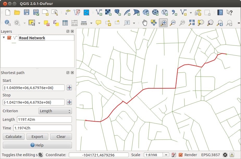
Plugin grafo strade 
Caratteristiche principali:
Calcola il percorso, la sua lunghezza ed il tempo di percorrenza
Ottimizza la lunghezza ed il tempo di percorrenza
Esporta il percorso in un layer vettoriale
Evidenzia la direzione delle strade (tale funzionalità è lenta e dovrebbe essere usata solo in fase di test)
As a roads layer you can use any polyline vector layer in any QGIS supported format. Two lines with a common point are considered connected. Please note, it is required to use layer CRS as project CRS while editing roads layer. This is due to the fact that recalculation of the coordinates between different CRS introduce some errors that can result in discontinuities, even when ‘snapping’ is used.
Nella tabella degli attributi del layer si possono usare i seguenti campi:
Velocità su sezione di strada — numerico
Direzione — testo (avanti, inversa, a doppio senso)
Se alcuni campi non hanno valori, o non esistono, vengono utilizzati dei valori predefiniti. Si possono cambiare alcune impostazioni predefinite nel menu impostazioni del plugin.
Utilizzo del plugin
After plugin activation you will see an additional panel on the left side of the main QGIS window. Now make some definitions to the Road graph plugin settings dialog in the menu Vector ‣ Road Graph (see figure_road_graph_2).
Figure Road Graph 2:
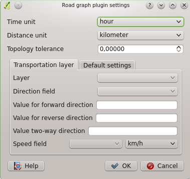
Road graph plugin settings
After setting the Time unit, Distance unit and Topology tolerance you can choose the vector layer in the Transportation layer tab. Here you can also choose the Direction field and Speed field. In the Default settings tab you can set the Direction for the calculation.
Finally in the Shortest Path panel select a Start and a Stop point in the road network layer and click on [Calculate].