Expresiones
- Lista de funciones
- Operadores
- Condicionales
- Funciones Matemáticas
- Funciones de Color
- Conversiones
- Funciones personalizadas
- Funciones de Fecha y Hora
- Campos y Valores
- Funciones Concordancia aproximada
- Funciones Generales
- Funciones de Geometría
- Registro Funciones
- Funciones de cadena
- Funciones recientes
- Variables Functions
- Editor de Funciones
The Expressions feature is available from many parts in QGIS. It can be
accessed using the  Expression Builder, the
 Select By Expression..., the Geometry generator
symbol layer option, the
Select By Expression..., the Geometry generator
symbol layer option, the  Field calculator or the
 Data defined override tool.
Based on layer data and prebuilt or user defined functions,
it offers a powerful way to manipulate attribute value, geometry and variables in
order to dynamically change the geometry style, the content or position
of the label, the value for diagram, the height of a composer item,
select some features, create virtual field ...
Data defined override tool.
Based on layer data and prebuilt or user defined functions,
it offers a powerful way to manipulate attribute value, geometry and variables in
order to dynamically change the geometry style, the content or position
of the label, the value for diagram, the height of a composer item,
select some features, create virtual field ...
Algún ejemplo:
From Field Calculator, calculate a “pop_density” field using existing “total_pop” and “area_km2” fields:
"total_pop" / "area_km2"
Update the field “density_level” with categories according to the “pop_density” values:
CASE WHEN "pop_density" < 50 THEN 'Low population density'
     WHEN "pop_density" >= 50 and "pop_density" < 150 THEN 'Medium population density'
     WHEN "pop_density" >= 150 THEN 'High population density'
END
Apply a categorized style to all the features according to whether their average house price is smaller or higher than 10000€ per square metre:
"price_m2" > 10000
Using the “Select By Expression...” tool, select all the features representing areas of “High population density” and whose average house price is higher than 10000€ per square metre:
"density_level" = 'High population density' and "price_m2" > 10000
Likewise, the previous expression could also be used to define which features should be labeled or shown in the map. Using expressions offers you a lot of possibilities.
The Expressions feature offers access to the:
- Expression tab which lists functions to use
- Function Editor tab which helps to create custom functions to use in the expressions.
Lista de funciones
Figure Expression 1:
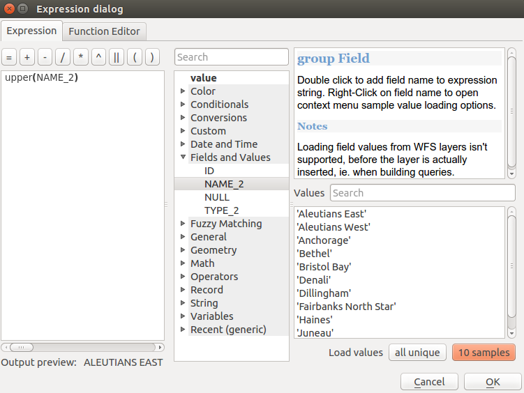
The Expression tab
The Expression tab contains functions as well as layer’s fields and values. It contains widgets to:
- type expressions using functions and/or fields. A preview of the expression’s result is displayed at the bottom of the dialog.
- select the appropriate function among a list. A search box is available to filter the list and quickly find a particular function or field. Double-clicking on the item’s name adds it to the expression being written.
- display help for each function selected. When a field is selected, this widget shows a sample of its values. Double-clicking a value adds it to the expression.
To help to quickly find a function, they are organized in groups. In Operators, you find mathematical operators. Look in Math for mathematical functions. The Conversions group contains functions that convert one data type to another. The String group provides functions for data strings, such as Date and Time handles date and time data. In the Geometry group, you find functions for geometry objects. With Record group functions, you can add a numeration to your data set while Fields and Values group helps view all attributes of the attribute table. The Customs group lists the functions created or imported by the user. There are many other groups, listed below.
Operadores
This group contains operators (e.g., +, -, *). Note that for most of the mathematical functions below, if one of the inputs is NULL then the result is NULL.
Función |
Descripción |
|---|---|
| a + b | Addition of two values (a plus b) |
| a - b | Subtraction of two values (a minus b). |
| a * b | Multiplication of two values (a multiplied by b) |
| a / b | División de dos valores (a dividido entre b) |
| a % b | Remainder of division of a by b (eg, 7 % 2 = 1, or 2 fits into 7 three times with remainder 1) |
| a ^ b | Power of two values (for example, 2^2=4 or 2^3=8) |
| a < b | Compares two values and evaluates to 1 if the left value is less than the right value (a is smaller than b) |
| a <= b | Compara dos valores y evalúa a 1 si el valor de la izquierda es menor que o igual que el valor de la derecha |
| a <> b | Compara dos valores y evalúa a 1 si no son iguales |
| a = b | Compara dos valores y evalúa a 1 si son iguales. |
| a != b | a and b are not equal |
| a > b | Compara dos valores y evalúa como 1 si el valor izquierdo es mayor que el valor derecho (a es mayor que b) |
| a >= b | Compara dos valores y evalúa a 1 si el valor de la izquierda es mayor que o igual que el valor de la derecha |
| a ~ b | a matches the regular expression b |
| || | Joins two values together into a string. If one of the values is NULL the result will be NULL |
| ‘\n’ | Inserta una nueva línea en una cadena |
| LIKE | Devuelve 1 si el primer parámetro coincide con el patrón provisto |
| ILIKE | Returns 1 if the first parameter matches case-insensitive the supplied pattern (ILIKE can be used instead of LIKE to make the match case-insensitive) |
| a IS b | Tests whether two values are identical. Returns 1 if a is the same as b |
| a OR b | Devuelve 1 cuando condición a or b es verdadera |
| a AND b | Devuelve 1 cuando las condiciones a y b son verdaderas |
| NOT | Niega una condición |
| column name “column name” | Value of the field column name, take care to not be confused with simple quote, see below |
‘cadena’ |
a string value, take care to not be confused with double quote, see above |
| NULL | valor nulo |
| a IS NULL | a no tiene valor |
| a IS NOT NULL | a tiene valor |
| a IN (value[,value]) | a esta debajo de los valores listados |
a NOT IN (valor[,valor]) |
a no está debajo de los valores listados |
Algún ejemplo:
Une una cadena de texto y un valor de un nombre de columna:
'My feature''s id is: ' || "gid"
Test if the “description” attribute field starts with the ‘Hello’ string in the value (note the position of the % character):
"description" LIKE 'Hello%'
Condicionales
Este grupo contiene funciones para menejar comprobaciones condicionales en expresiones.
Función |
Descripción |
|---|---|
| CASE WHEN ... THEN ... END | Evalúa una expresión y devuelve un resultado si es verdadera. Puede probar múltiples condiciones |
| CASE WHEN ... THEN ... ELSE ... END | Evalúa una expresión y devuelva un resultado diferente sea verdadero o falso. Puede probar múltiples condiciones |
| coalesce | Devuelve el primer valor no-NULO de la lista de expresión |
si |
Prueba una condición y devuelve un resultado diferente dependiendo de la comprobación condicional |
| regexp_match | Devuelve verdadero si cualquier parte de una cadena coincide con la expresión regular proporcionada |
Algún ejemplo:
Send back a value if the first condition is true, else another value:
CASE WHEN "software" LIKE '%QGIS%' THEN 'QGIS' ELSE 'Other' END
Funciones Matemáticas
Este grupo contiene funciones matemáticas,por ejemplo raíz cuadrada, seno y coseno
Función |
Descripción |
|---|---|
| abs | Devuelve el valor absoluto de un número |
arcos |
Devuelve la inversa del coseno de un valor en radianes |
arcsen |
Devuelve la inversa del seno de un valor en radianes |
| atan | Devuelve la inversa del coseno de un valor en radianes |
| atan2(y,x) | Returns the inverse tangent of y/x by using the signs of the two arguments to determine the quadrant of the result |
| azimuth(a,b) | Returns the north-based azimuth as the angle in radians measured clockwise from the vertical on point a to point b |
| ceil | Rounds a number upwards |
| clamp | Restricts an input value to a specified range |
| cos | Devuelve el coseno de un valor en radianes |
grados |
Convierte de radianes a grados |
| exp | Devuelve la exponencial de un valor |
| floor | Rounds a number downwards |
| ln | Returns the natural logarithm of the passed expression |
| log | Returns the value of the logarithm of the passed value and base |
| log10 | Returns the value of the base 10 logarithm of the passed expression |
máx |
Returns the largest value in a set of values |
mín |
Returns the smallest value in a set of values |
| pi | Returns the value of pi for calculations |
radianes |
Convierte de grados a radianes |
| rand | Returns the random integer within the range specified by the minimum and maximum argument (inclusive) |
| randf | Returns the random float within the range specified by the minimum and maximum argument (inclusive) |
| round | Rounds to number of decimal places |
| scale_exp | Transforma un valor dado de un dominio de entrada a un rango de salida usando una curva exponencial |
| scale_linear | Transforma un valor dado de un dominio de entrada a un rango de salida usando interpolación lineal |
sen |
Returns the sine of an angle |
raíz cuadrada |
Returns the square root of a value |
| tan | Returns the tangent of an angle |
Funciones de Color
This group contains functions for manipulating colors.
Función |
Descripción |
|---|---|
| color_cmyk | Devuelve una representación en forma de cadena de un color en base a sus componentes cian, magenta, amarillo y negro |
| color_cmyka | Returns a string representation of a color based on its cyan, magenta, yellow, black and alpha (transparency) components |
| color_hsl | Returns a string representation of a color based on its hue, saturation, and lightness attributes |
| color_hsla | Devuelve una representación en forma de cadena de un color en base a sus atributos de matiz, saturación, luminosidad y canal alfa (transparencia). |
| color_hsv | Returns a string representation of a color based on its hue, saturation, and value attributes |
| color_hsva | Devuelve una representación en forma de cadena de un color en base a sus atributos de matiz, saturación, valor y canal alfa (transparencia) |
| color_part | Devuelve un componente específico de la cadena de un color, por ejemplo el componente rojo o el alfa |
| color_rgb | Returns a string representation of a color based on its red, green, and blue components |
| color_rgba | Returns a string representation of a color based on its red, green, blue, and alpha (transparency) components |
más oscuro |
Devuelve una cadena de color más oscura (o más clara) |
más claro |
Devuelve una cadena de color más clara (o más oscura) |
| project_color | Devuelve un color del esquema de color del proyecto |
| ramp_color | Devuelve una cadena que representa un color de una rampa de color |
| set_color_part | Sets a specific color component for a color string, eg the red component or alpha component |
Conversiones
This group contains functions to convert one data type to another (e.g., string to integer, integer to string).
Función |
Descripción |
|---|---|
| to_date | Convierte una cadena de texto en un objeto fecha |
| to_datetime | Converts a string into a datetime object |
| to_int | Convierte una cadena de texto a número entero |
| to_interval | Converts a string to an interval type (can be used to take days, hours, months, etc. of a date) |
| to_real | Convierte una cadena de texto en número real |
| to_string | Converts number to string |
| to_time | Converts a string into a time object |
Funciones personalizadas
This group contains functions created by the user. See function_editor for more details.
Funciones de Fecha y Hora
Este grupo contiene funciones para manipular datos de fecha y hora.
Función |
Descripción |
|---|---|
edad |
Returns as an interval the difference between two dates or datetimes |
día |
Extracts the day from a date or datetime, or the number of days from an interval |
| day_of_week | Returns a number corresponding to the day of the week for a specified date or datetime |
hora |
Extracts the hour from a datetime or time, or the number of hours from an interval |
minuto |
Extracts the minute from a datetime or time, or the number of minutes from an interval |
mes |
Extracts the month part from a date or datetime, or the number of months from an interval |
| now() | Returns current date and time |
segundo |
Extracts the second from a datetime or time, or the number of seconds from an interval |
semana |
Extrae el número de la semana de una fecha o el número de semanas de un intervalo. |
| year | Extracts the year part from a date or datetime, or the number of years from an interval |
Algún ejemplo:
Get the month and the year of today in the format “10/2014”
month(now()) || '/' || year(now())
Campos y Valores
Contains a list of fields from the layer.
Generally, you can use the various fields, values and functions to construct the calculation expression, or you can just type it into the box.
To display the values of a field, you just click on the appropriate field and choose between Load top 10 unique values and Load all unique values. On the right side, the Field Values list opens with the unique values. At the top of the list, a search box helps filtering the values. To add a value to the expression you are writing, double click its name in the list.
También se puede acceder a datos de muestra vía clic derecho. Seleccione el nombre del campo de la lista, luego haga clic derecho para acceder al menú contextual con opciones para cargar valores de muestra del campo seleccionado.
Fields name should be double-quoted in the expression. Values or string should be simple-quoted.
Funciones Concordancia aproximada
This group contains functions for fuzzy comparisons between values.
Función |
Descripción |
|---|---|
| hamming_distance | Returns the number of characters at corresponding positions within the input strings where the characters are different |
| levensheim | Returns the minimum number of character edits (insertions, deletions or substitutions) required to change one string to another. Measure the similarity between two strings |
| longest_common_substring | Returns the longest common substring between two strings |
| soundex | Returns the Soundex representation of a string |
Funciones Generales
Este grupo contiene funciones generales variadas.
Función |
Descripción |
|---|---|
| eval | Evaluates an expression which is passed in a string. Useful to expand dynamic parameters passed as context variables or fields |
| layer_property | Returns a property of a layer or a value of its metadata. It can be layer name, crs, geometry type, feature count... |
| var | Returns the value stored within a specified variable. See variable functions below |
Funciones de Geometría
This group contains functions that operate on geometry objects (e.g., length, area).
Función |
Descripción |
|---|---|
| $area | Returns the area size of the current feature |
| $geometry | Returns the geometry of the current feature (can be used for processing with other functions) |
| $length | Returns the length of the current line feature |
| $perimeter | Returns the perimeter of the current polygon feature |
| $x | Returns the x coordinate of the current feature |
| $x_at(n) | Returns the x coordinate of the nth node of the current feature’s geometry |
| $y | Devuelve la coordenada Y del objeto actual |
| $y_at(n) | Returns the y coordinate of the nth node of the current feature’s geometry |
| area | Devuelve el perímetro de un objeto de geometría poligonal. Los cálculos están en el Sistema de Referencia Espacial de esta geometría |
límites |
Returns a geometry which represents the bounding box of an input geometry. Calculations are in the Spatial Reference System of this Geometry |
| bounds_height | Returns the height of the bounding box of a geometry. Calculations are in the Spatial Reference System of this Geometry |
| bounds_width | Devuelve la anchura del recuadro delimitador de una geometría. Los cálculos están en el Sistema de Referencia Espacial de esta geometría |
| buffer | Returns a geometry that represents all points whose distance from this geometry is less than or equal to distance. Calculations are in the Spatial Reference System of this geometry |
| centroid | Devuelve el centro geométrico de una geometría |
| closest_point | Returns the point on a geometry that is closest to a second geometry |
combinar |
Devuelve la combinación de dos geometrías |
| contains(a,b) | Returns 1 (true) if and only if no points of b lie in the exterior of a, and at least one point of the interior of b lies in the interior of a |
| convex_hull | Returns the convex hull of a geometry (this represents the minimum convex geometry that encloses all geometries within the set) |
cruza |
Returns 1 (true) if the supplied geometries have some, but not all, interior points in common |
| difference(a,b) | Returns a geometry that represents that part of geometry a that does not intersect with geometry b |
inconexo |
Returns 1 (true) if the geometries do not share any space together |
| distance | Returns the minimum distance (based on spatial ref) between two geometries in projected units |
| end_point | Devuelve el último nodo de una geometría |
| exterior_ring | Devuelve una cadena de línea que representa el anillo exterior de una geometría de tipo polígono. Si la geometría no es un polígono entonces el resultado será nulo |
| extrude(geom,x,y) | Returns an extruded version of the input (Multi-)Curve or (Multi-)Linestring geometry with an extension specified by x and y |
| geom_from_gml | Returns a geometry created from a GML representation of geometry |
| geom_from_wkt | Returns a geometry created from a well-known text (WKT) representation |
| geom_to_wkt | Returns the well-known text (WKT) representation of the geometry without SRID metadata |
| geometry | Devuelve la geometría de un objeto |
| geometry_n | Returns the nth geometry from a geometry collection, or null if the input geometry is not a collection |
| interior_ring_n | Returns the geometry of the nth interior ring from a polygon geometry, or null if the geometry is not a polygon |
intersección |
Returns a geometry that represents the shared portion of two geometries |
intersecta |
Tests whether a geometry intersects another. Returns 1 (true) if the geometries spatially intersect (share any portion of space) and 0 if they don’t |
| intersects_bbox | Tests whether a geometry’s bounding box overlaps another geometry’s bounding box. Returns 1 (true) if the geometries spatially intersect (share any portion of space) their bounding box and 0 if they don’t |
| is_closed | Returns true if a line string is closed (start and end points are coincident), false if a line string is not closed and null if the geometry is not a line string |
longitud |
Returns length of a line geometry feature (or length of a string) |
| m | Returns the m value of a point geometry |
| make_line | Crea una geometría de línea a partir de una serie de geometrías de puntos |
| make_point(x,y,z,m) | Returns a point geometry from x and y values (and optional z and m values) |
| make_point_m(x,y,m) | Returns a point geometry from x and y coordinates and m values |
| make_polygon | Crea una geometría de polígono a partir de un anillo exterior y series opcionales de geometrías interiores de anillo |
| nodes_to_points | Devuelve una geometría multipunto consistente en cada nodo de la geometría de entrada |
| num_geometries | Devuelve el número de geometrías en una colección de geometrías o nulo si la geometría de entrada no es una colección |
| num_interior_rings | Devuelve el número de anillos interiores de un polígono o una colección de geometrías o nulo si la geometría de entrada no es un polígono o una colección |
| num_points | Devuelve el número de vértices de una geometría. |
| num_rings | Devuelve el número de anillos (incluidos los anillos exteriores) de un polígono o una colección de geometrías o nulo si la geometría de entrada no es un polígono o una colección |
| order_parts | Ordena las partes de una MultiGeometría por los criterios dados |
solapa |
Comprueba si una geometría solapa con otra. Devuelve 1(verdadero) si las geometrías comparten espacio, son de la misma dimensión, pero no están contenidas en la otra. |
perímetro |
Devuelve el perímetro de un objeto de geometría poligonal. Los cálculos están en el Sistema de Referencia Espacial de esta geometría. |
| point_n | Returns a specific node from a geometry |
| point_on_surface | Devuelve un punto garantizando que cae en la superficie de una geometría |
| relate | Prueba o devuelve la representación del Modelo de Intersección 9 Extendido Dimensional (DE-9IM) de la relación entre dos geometrías. |
invertir |
Reverses the direction of a line string by reversing the order of its vertices |
| segments_to_lines | Returns a multi line geometry consisting of a line for every segment in the input geometry |
| shortest_line | Returns the shortest line joining two geometries. The resultant line will start at geometry 1 and end at geometry 2 |
| start_point | Devuelve el primer nodo de una geometría |
| sym_difference | Devuelve una geometría que representa las partes de dos geometrías que no intersectan |
toca |
Tests whether a geometry touches another. Returns 1 (true) if the geometries have at least one point in common, but their interiors do not intersect |
Transformar |
Returns the geometry transformed from the source CRS to the destination CRS |
Convertir |
Returns a translated version of a geometry. Calculations are in the Spatial Reference System of this geometry |
unión |
Devuelve una geometría que representa el conjunto unión de los puntos de las geometrías. |
entre(a,b) |
Tests whether a geometry is within another. Returns 1 (true) if geometry a is completely inside geometry b |
| x | Devuelve la coordenada X de una geometría de tipo punto o la coordenada X del centroide de una geometría que no sea de puntos. |
| x_min | Devuelve la coordenada X mínima de una geometría. Los cálculos están en el Sistema de Referencia Espacial de esta geometría |
| x_max | Devuelve la coordenada X mínima de una geometría. Los cálculos están en el Sistema de Referencia Espacial de esta geometría |
| y | Devuelve la coordenada Y de una geometría de tipo punto o la coordenada Y del centroide de una geometría que no sea de puntos. |
| y_min | Devuelve la coordenada Y mínima de una geometría. Los cálculos están en el Sistema de Referencia Espacial de esta geometría |
| y_max | Returns the maximum y coordinate of a geometry. Calculations are in the Spatial Reference System of this geometry |
| z | Devuelve la coordenada Z de una geometría de punto |
Algún ejemplo:
Return the x coordinate of the current feature’s centroid:
x($geometry)
Send back a value according to feature’s area:
CASE WHEN $area > 10 000 THEN 'Larger' ELSE 'Smaller' END
Registro Funciones
Este grupo contiene funciones que operan sobre identificadores de registros.
Función |
Descripción |
|---|---|
| $currentfeature | Devuelve el objeto espacial que está siendo evaluado. Se puede usar con la función ‘attribute’ para evaluar los valores de atributo del objeto actual. |
| $id | Devuelve el ID del objeto de la fila actual |
| $map | Devuelve la ID del elemento actual del mapa si se está dibujando el mapa en una composición o “lienzo” si el mapa se está dibujando dentro de la ventana principal de QGIS |
| $rownum | Devuelve el número de la fila actual |
| $scale | Devuelve la escala actual de la vista del mapa |
atributo |
Devuelve el valor del atributo especificado de un objeto. |
| get_feature | Devuelve el primer objeto de una capa que coincide con un valor de atributo dado. |
| uuid | Generates a Universally Unique Identifier (UUID) for each row. Each UUID is 38 characters long |
Algún ejemplo:
Return the first feature in layer “LayerA” whose field “id” has the same value as the field “name” of the current feature (a kind of jointure):
get_feature( 'layerA', 'id', attribute( $currentfeature, 'name') )
Calculate the area of the joined feature from the previous example:
area( geometry( get_feature( 'layerA', 'id', attribute( $currentfeature, 'name') ) ) )
Funciones de cadena
This group contains functions that operate on strings (e.g., that replace, convert to upper case).
Función |
Descripción |
|---|---|
| concat | Concatenates several strings to one |
| format | Formats a string using supplied arguments |
| format_date | Formats a date type or string into a custom string format |
| format_number | Devuelve un número formateado con el separador local de miles (también trunca el número al número de decimales indicado) |
| left(string, n) | Returns a substring that contains the n leftmost characters of the string |
longitud |
Returns length of a string (or length of a line geometry feature) |
| lower | Convierte una cadena a letras minúsculas. |
| lpad | Devuelve una cadena en la que se ha remplazado la cadena proporcionada usando un carácter de relleno. |
| regexp_replace | Returns a string with the supplied regular expression replaced |
| regexp_substr | Devuelve la parte de una cadena que coincide con una expresión regular proporcionada |
remplazar |
Devuelve una cadena en la que se ha remplazado la cadena proporcionada. |
right(cadena, n) |
Devuelve una subcadena que contiene los n caracteres más a la derecha de la cadena. |
| rpad | Devuelve una cadena en la que se ha remplazado la cadena proporcionada usando un carácter de relleno. |
| strpos | Returns the index of a regular expression in a string |
| substr | Devuelve una parte de una cadena. |
Título |
Convierte todas las palabras de una cadena a formato de título (todas las palabras en minúscula con la primera letra en mayúscula) |
| trim | Elimina todos los espacios en blanco (espacios, tabuladores, etc.) de comienzo y final de una cadena. |
| upper | Convierte una cadena a letras mayúsculas. |
| wordwrap | Devuelve una cadena ajustada un número de caracteres máximo/mínimo |
Funciones recientes
This group contains recently used functions. Any expression used in the Expression dialog is added to the list, sorted from the more recent to the less one. This helps to quickly retrieve any previous expression.
Variables Functions
This group contains dynamic variables related to the application, the project file and other settings. It means that some functions may not be available according to the context:
- from the Select by expression dialog
- from the Field calculator dialog
- from the layer properties dialog
desde el diseñador de impresión
To use these functions in an expression, they should be preceded by @ character (e.g, @row_number). Are concerned:
Función |
Descripción |
|---|---|
| atlas_feature | Devuelve el objeto del atlas actual (como objeto espacial) |
| atlas_featureid | Devuelve el ID de objeto del atlas actual. |
| atlas_featurenumber | Devuelve el número de páginas de la composición |
| atlas_filename | Devuelve el nombre de archivo del atlas actual. |
| atlas_geometry | Devuelve la geometría de objeto del atlas actual |
| atlas_pagename | Devuelve el nombre de la página del atlas actual |
| atlas_totalfeatures | Devuelve el número total de objetos en el atlas. |
| grid_axis | Devuelve el eje de la anotación de la cuadrícula actual (ej.: ‘x’ para longitud, ‘y’ para latitud). |
| grid_number | Devuelve el valor de anotación de la cuadrícula actual. |
| item_id | Returns the composer item user ID (not necessarily unique) |
| item_uuid | Devuelve el ID único del elemento del diseñador |
| layer_id | Devuelve el ID de la capa actual |
| layer_name | Devuelve el nombre de la capa actual |
| layout_dpi | Devulve la resolución de la composición (DPI). |
| layout_numpages | Devuelve el número de páginas de la composición. |
| layout_pageheight | Devuelve la anchura de la composición en mm. |
| layout_pagewidth | Devuelve la anchura de la composición en mm. |
| map_id | Devuelve el ID del destino actual del mapa. Será ‘lienzo’ para renderizadores de la vista del mapa y la ID del elemento para renderizadores del diseñador de mapas. |
| map_extent_center | Returns the point feature at the center of the map |
| map_extent_height | Devuelve la altura actual del mapa |
| map_extent_width | Devuelve el ancho actual del mapa |
| map_rotation | Devuelve la rotación actual del mapa |
| map_scale | Devuelve la escala actual del mapa |
| project_filename | Devuelve el nombre del proyecto actual |
| project_folder | Devuelve la carpeta del proyecto actual. |
| project_path | Devuelve la ruta completa (incluido el nombre de archivo) del proyecto actual. |
| project_title | Devuelve el Título del proyecto actual. |
| qgis_os_name | Devuelve el nombre del sistema operativo, ej. ‘Windows’, ‘Linux’ o ‘OSX’. |
| qgis_platform | Devuelve la plataforma de QGIS, ej. ‘Escritorio’ o ‘Servidor’. |
| qgis_release_name | Devuelve el nombre de la versión actual de QGIS |
| qgis_version | Devuelve la versión actual de QGIS como cadena |
| qgis_version_no | Devuelve la versión actual de QGIS como número |
| symbol_angle | Devuelve el ángulo del símbolo usado para representar el objeto (solo válido para símbolos de marcador). |
| symbol_color | Returns the color of the symbol used to render the feature |
| user_account_name | Devuelve el nombre de la cuenta del sistema operativo del usuario actual. |
| user_full_name | Devuelve el nombre de usuario del sistema operativo del usuario actual. |
| row_number | Guarda el número de la fila actual. |
Editor de Funciones
With the Function Editor, you are able to define your own Python custom functions in a comfortable way.
Figure Expression 2:
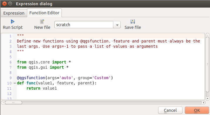
The Function Editor tab
The function editor will create new Python files in .qgis2\python\expressions folder and will auto load all functions defined when starting QGIS. Be aware that new functions are only saved in the expressions folder and not in the project file. If you have a project that uses one of your custom functions you will need to also share the .py file in the expressions folder.
Here’s a short example on how to create your own functions:
@qgsfunction(args="auto", group='Custom')
def myfunc(value1, value2, feature, parent):
    pass
The short example creates a function ‘myfunc’ that will give you a function with two values. When using the args=’auto’ function argument the number of function arguments required will be calculated by the number of arguments the function has been defined with in Python (minus 2 - feature, and parent).
This function then can be used with the following expression:
myfunc('test1', 'test2')
Your function will be implemented in the Custom functions group of the Expression tab after using the Run Script button.
Further information about creating Python code can be found in the Libro de Recetas para Desarrollador PyQGIS.
The function editor is not only limited to working with the field calculator, it can be found whenever you work with expressions.