Expresiones
Based on layer data and prebuilt or user defined functions, Expressions offer a powerful way to manipulate attribute value, geometry and variables in order to dynamically change the geometry style, the content or position of the label, the value for diagram, the height of a layout item, select some features, create virtual field …
The Expression string builder
Main dialog to build expressions, the Expression string builder is available from many parts in QGIS and, can particularly be accessed when:
clicking the
 button;
selecting features with the
 Select By Expression… tool;
editing attributes with e.g. the
 Field calculator tool;
manipulating symbology, label or layout item parameters with the
 Data defined override tool (see Configuración de anulación definida por datos);
building a geometry generator symbol layer;
doing some geoprocessing.
The Expression builder dialog offers access to the:
Expression tab which, thanks to a list of predefined functions, helps to write and check the expression to use;
Function Editor tab which helps to extend the list of functions by creating custom ones.
Some use cases of expressions:
From Field Calculator, calculate a «pop_density» field using existing «total_pop» and «area_km2» fields:
"total_pop" / "area_km2"
Update the field «density_level» with categories according to the «pop_density» values:
CASE WHEN "pop_density" < 50 THEN 'Low population density'
     WHEN "pop_density" >= 50 and "pop_density" < 150 THEN 'Medium population density'
     WHEN "pop_density" >= 150 THEN 'High population density'
END
Apply a categorized style to all the features according to whether their average house price is smaller or higher than 10000€ per square metre:
"price_m2" > 10000
Using the «Select By Expression…» tool, select all the features representing areas of “High population density” and whose average house price is higher than 10000€ per square metre:
"density_level" = 'High population density' and "price_m2" > 10000
Likewise, the previous expression could also be used to define which features should be labeled or shown in the map.
Using expressions offers you a lot of possibilities.
Truco
Use named parameters to improve the expression reading
Some functions require many parameters to be set. The expression engine supports the
use of named parameters. This means that instead of writing the cryptic expression
clamp( 1, 2, 9), you can use clamp( min:=1, value:=2, max:=9). This also allows
arguments to be switched, e.g. clamp( value:=2, max:=9, min:=1). Using named parameters
helps clarify what the arguments for an expression function refer to, which is helpful
when you are trying to interpret an expression at a later date!
Lista de funciones
The Expression tab provides the main interface to write expressions using functions, layer’s fields and values. It contains following widgets:
An expression editor area to type or paste expressions. Autocompletion is available to speed expression writing:
Corresponding variables, function names and field names to the input text are shown below: use the Up and Down arrows to browse the items and press Tab to insert in the expression or simply click on the wished item.
Function parameters are shown while filling them.
QGIS also checks the expression rightness and highlights all the errors using:
Underline: for unknown functions, wrong or invalid arguments;
Marker: for every other error (eg, missing parenthesis, unexpected character) at a single location.
Truco
Document your expression with comments
When using complex expression, it is good practice to add text either as a multiline comment or inline comments to help you remember.
/*
Labels each region with its highest (in altitude) airport(s)
and altitude, eg 'AMBLER : 264m' for the 'Northwest Artic' region
*/
with_variable(
  'airport_alti', -- stores the highest altitude of the region
  aggregate(
    'airports',
    'max',
    "ELEV", -- the field containing the altitude
    -- and limit the airports to the region they are within
    filter := within( $geometry, geometry( @parent ) )
  ),
    aggregate( -- finds airports at the same altitude in the region
      'airports',
      'concatenate',
      "NAME",
      filter := within( $geometry, geometry( @parent ) )
        and "ELEV" = @airport_alti
    )
    || ' : ' || @airport_alti || 'm'
    -- using || allows regions without airports to be skipped
)
Under the expression editor, an Output preview displays the result of the expression evaluated on the first feature of the layer. In case of error, it indicates it and you can access details with the provided hyperlink.
A function selector displays the list of functions, variables, fields… organized in groups. A search box is available to filter the list and quickly find a particular function or field. Double-clicking an item adds it to the expression editor.
A help panel displays help for each selected item in the function selector.
Truco
Press Ctrl+Click when hovering a function name in an expression to automatically display its help in the dialog.
A field’s values widget shown when a field is selected in the function selector helps to fetch features attributes. Double-clicking a value adds it to the expression editor.
Truco
The right panel, showing functions help or field values, can be collapsed (invisible) in the dialog. Press the Show Values or Show Help button to get it back.
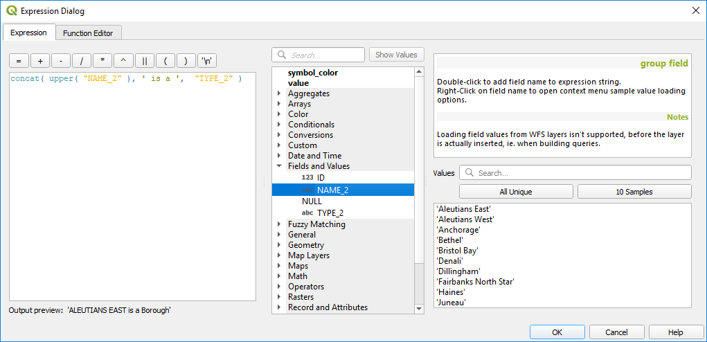
The Expression tab
Aggregates Functions
This group contains functions which aggregate values over layers and fields.
Función |
Descripción |
|---|---|
agregar |
Returns an aggregate value calculated using features from another layer |
array_agg |
Returns an array of aggregated values from a field or expression |
collect |
Returns the multipart geometry of aggregated geometries from an expression |
concatenar |
Returns the all aggregated strings from a field or expression joined by a delimiter |
Número |
Returns the count of matching features |
count_distinct |
Returns the count of distinct values |
count_missing |
Returns the count of missing (null) values |
iqr |
Returns the calculated inter quartile range from a field or expression |
mayoría |
Returns the aggregate majority of values (most commonly occurring value) from a field or expression |
max_length |
Returns the maximum length of strings from a field or expression |
máximo |
Returns the aggregate maximum value from a field or expression |
media |
Returns the aggregate mean value from a field or expression |
mediana |
Returns the aggregate median value from a field or expression |
min_length |
Returns the minimum length of strings from a field or expression |
mínimo |
Returns the aggregate minimum value from a field or expression |
minoría |
Returns the aggregate minority of values (least commonly occurring value) from a field or expression |
q1 |
Returns the calculated first quartile from a field or expression |
q3 |
Devuelve el tercer cuartil calculado a partir de un campo o expresión |
intervalo |
Returns the aggregate range of values (maximum - minimum) from a field or expression |
relation_aggregate |
Returns an aggregate value calculated using all matching child features from a layer relation |
stdev |
Returns the aggregate standard deviation value from a field or expression |
sum |
Returns the aggregate summed value from a field or expression |
Ejemplos:
Return the maximum of the «passengers» field from features in the layer grouped by «station_class» field:
maximum("passengers", group_by:="station_class")
Calculate the total number of passengers for the stations inside the current atlas feature:
aggregate('rail_stations','sum',"passengers",
  intersects(@atlas_geometry, $geometry))
Return the mean of the «field_from_related_table» field for all matching child features using the “my_relation” relation from the layer:
relation_aggregate('my_relation', 'mean', "field_from_related_table")
o:
relation_aggregate(relation:='my_relation', aggregate := 'mean',
  expression := "field_from_related_table")
Array Functions
This group contains functions to create and manipulate arrays (also known as list data structures). The order of values within the array matters, unlike the “map” data structure, where the order of key-value pairs is irrelevant and values are identified by their keys.
Función |
Descripción |
|---|---|
array |
Returns an array containing all the values passed as parameter |
array_append |
Returns an array with the given value added at the end |
array_cat |
Returns an array containing all the given arrays concatenated |
array_contains |
Returns true if an array contains the given value |
array_distinct |
Returns an array containing distinct values of the given array |
array_filter |
Returns an array with only the items for which an expression evaluates to true |
array_find |
Returns the index (0 for the first one) of a value within an array. Returns -1 if the value is not found. |
array_first |
Returns the first value of an array |
array_foreach |
Returns an array with the given expression evaluated on each item |
array_get |
Returns the Nth value (0 for the first one) of an array |
array_insert |
Returns an array with the given value added at the given position |
array_intersect |
Returns true if any element of array_1 exists in array_2 |
array_last |
Returns the last element of an array |
array_length |
Returns the number of elements of an array |
array_prepend |
Returns an array with the given value added at the beginning |
array_remove_all |
Returns an array with all the entries of the given value removed |
array_remove_at |
Returns an array with the given index removed |
array_reverse |
Returns the given array with array values in reversed order |
array_slice |
Returns the values of the array from the start_pos argument up to and including the end_pos argument |
array_to_string |
Concatenates array elements into a string separated by a delimiter and using optional string for empty values |
generate_series |
Creates an array containing a sequence of numbers |
regexp_matches |
Returns an array of all strings captured by capturing groups, in the order the groups themselves appear in the supplied regular expression against a string |
string_to_array |
Splits string into an array using supplied delimiter and optional string for empty values |
Funciones de Color
This group contains functions for manipulating colors.
Función |
Descripción |
|---|---|
color_cmyk |
Devuelve una representación en forma de cadena de un color en base a sus componentes cian, magenta, amarillo y negro |
color_cmyka |
Returns a string representation of a color based on its cyan, magenta, yellow, black and alpha (transparency) components |
color_grayscale_average |
Applies a grayscale filter and returns a string representation from a provided color |
color_hsl |
Returns a string representation of a color based on its hue, saturation, and lightness attributes |
color_hsla |
Devuelve una representación en forma de cadena de un color en base a sus atributos de matiz, saturación, luminosidad y canal alfa (transparencia). |
color_hsv |
Returns a string representation of a color based on its hue, saturation, and value attributes |
color_hsva |
Devuelve una representación en forma de cadena de un color en base a sus atributos de matiz, saturación, valor y canal alfa (transparencia) |
color_mix_rgb |
Returns a string representing a color mixing the red, green, blue, and alpha values of two provided colors based on a given ratio |
color_part |
Devuelve un componente específico de la cadena de un color, por ejemplo el componente rojo o el alfa |
color_rgb |
Returns a string representation of a color based on its red, green, and blue components |
color_rgba |
Returns a string representation of a color based on its red, green, blue, and alpha (transparency) components |
create_ramp |
Returns a gradient ramp from a map of color strings and steps |
más oscuro |
Devuelve una cadena de color más oscura (o más clara) |
más claro |
Devuelve una cadena de color más clara (o más oscura) |
project_color |
Devuelve un color del esquema de color del proyecto |
ramp_color |
Devuelve una cadena que representa un color de una rampa de color |
set_color_part |
Sets a specific color component for a color string, eg the red component or alpha component |
Conditional Functions
Este grupo contiene funciones para menejar comprobaciones condicionales en expresiones.
Función |
Descripción |
|---|---|
CASE WHEN … THEN … END |
Evalúa una expresión y devuelve un resultado si es verdadera. Puede probar múltiples condiciones |
CASE WHEN … THEN … ELSE … END |
Evalúa una expresión y devuelva un resultado diferente sea verdadero o falso. Puede probar múltiples condiciones |
coalesce |
Devuelve el primer valor no-NULO de la lista de expresión |
si |
Prueba una condición y devuelve un resultado diferente dependiendo de la comprobación condicional |
Algún ejemplo:
Send back a value if the first condition is true, else another value:
CASE WHEN "software" LIKE '%QGIS%' THEN 'QGIS' ELSE 'Other' END
Funciones de conversión
This group contains functions to convert one data type to another (e.g., string to integer, integer to string).
Función |
Descripción |
|---|---|
to_date |
Convierte una cadena de texto en un objeto fecha |
to_datetime |
Converts a string into a datetime object |
to_dm |
Converts a coordinate to degree, minute |
to_dms |
Converts coordinate to degree, minute, second |
to_int |
Convierte una cadena de texto a número entero |
to_interval |
Converts a string to an interval type (can be used to take days, hours, months, etc. of a date) |
to_real |
Convierte una cadena de texto en número real |
to_string |
Convierte un número en cadena. |
to_time |
Converts a string into a time object |
Funciones personalizadas
This group contains functions created by the user. See Editor de Funciones for more details.
Funciones de Fecha y Hora
Este grupo contiene funciones para manipular datos de fecha y hora.
Función |
Descripción |
|---|---|
edad |
Returns as an interval the difference between two dates or datetimes |
día |
Extracts the day from a date or datetime, or the number of days from an interval |
day_of_week |
Returns a number corresponding to the day of the week for a specified date or datetime |
epoch |
Returns the interval in milliseconds between the unix epoch and a given date value |
hora |
Extracts the hour from a datetime or time, or the number of hours from an interval |
minuto |
Extracts the minute from a datetime or time, or the number of minutes from an interval |
mes |
Extracts the month part from a date or datetime, or the number of months from an interval |
now |
Returns current date and time |
segundo |
Extracts the second from a datetime or time, or the number of seconds from an interval |
semana |
Extrae el número de la semana de una fecha o el número de semanas de un intervalo. |
year |
Extracts the year part from a date or datetime, or the number of years from an interval |
This group also shares several functions with the Funciones de conversión ( to_date, to_time, to_datetime, to_interval) and Funciones de cadena (format_date) groups.
Algún ejemplo:
Get today’s month and year in the «month_number/year» format:
format_date(now(),'MM/yyyy')
-- Returns '03/2017'
Besides these functions, subtracting dates, datetimes or times using the
- (minus) operator will return an interval.
Adding or subtracting an interval to dates, datetimes or times, using the
+ (plus) and - (minus) operators, will return a datetime.
Get the number of days until QGIS 3.0 release:
to_date('2017-09-29') - to_date(now())
-- Returns <interval: 203 days>
The same with time:
to_datetime('2017-09-29 12:00:00') - to_datetime(now())
-- Returns <interval: 202.49 days>
Get the datetime of 100 days from now:
now() + to_interval('100 days')
-- Returns <datetime: 2017-06-18 01:00:00>
Nota
Storing date and datetime and intervals on fields
The ability to store date, time and datetime values directly on fields may depend on the data source’s provider (e.g., Shapefile accepts date format, but not datetime or time format). The following are some suggestions to overcome this limitation:
date, Datetime and time can be stored in text type fields after using the
to_format()function.Intervals can be stored in integer or decimal type fields after using one of the date extraction functions (e.g.,
day()to get the interval expressed in days)
Campos y Valores
Contains a list of fields from the layer.
Double-click a field name to have it added to your expression. You can also type the field name (preferably inside double quotes) or its alias.
To retrieve fields values to use in an expression, select the appropriate field and, in the shown widget, choose between 10 Samples and All Unique. Requested values are then displayed and you can use the Search box at the top of the list to filter the result. Sample values can also be accessed via right-clicking on a field.
To add a value to the expression you are writing, double-click on it in the list. If the value is of a string type, it should be simple quoted, otherwise no quote is needed.
Funciones Concordancia aproximada
This group contains functions for fuzzy comparisons between values.
Función |
Descripción |
|---|---|
hamming_distance |
Returns the number of characters at corresponding positions within the input strings where the characters are different |
levensheim |
Returns the minimum number of character edits (insertions, deletions or substitutions) required to change one string to another. Measure the similarity between two strings |
longest_common_substring |
Returns the longest common substring between two strings |
soundex |
Returns the Soundex representation of a string |
Funciones Generales
Este grupo contiene funciones generales variadas.
Función |
Descripción |
|---|---|
env |
Gets an environment variable and returns its content
as a string. If the variable is not found, |
eval |
Evaluates an expression which is passed in a string. Useful to expand dynamic parameters passed as context variables or fields |
is_layer_visible |
Returns true if a specified layer is visible |
layer_property |
Returns a property of a layer or a value of its metadata. It can be layer name, crs, geometry type, feature count… |
var |
Returns the value stored within a specified variable. See variable functions below |
with_variable |
Creates and sets a variable for any expression code that will be provided as a third argument. Useful to avoid repetition in expressions where the same value needs to be used more than once. |
Funciones de Geometría
This group contains functions that operate on geometry objects (e.g., length, area).
Función |
Descripción |
|---|---|
$area |
Returns the area size of the current feature |
$geometry |
Returns the geometry of the current feature (can be used for processing with other functions) |
$length |
Returns the length of the current line feature |
$perimeter |
Returns the perimeter of the current polygon feature |
$x |
Returns the X coordinate of the current feature |
$x_at(n) |
Returns the X coordinate of the nth node of the current feature’s geometry |
$y |
Returns the Y coordinate of the current feature |
$y_at(n) |
Returns the Y coordinate of the nth node of the current feature’s geometry |
angle_at_vertex |
Returns the bisector angle (average angle) to the geometry for a specified vertex on a linestring geometry. Angles are in degrees clockwise from north |
area |
Devuelve el perímetro de un objeto de geometría poligonal. Los cálculos están en el Sistema de Referencia Espacial de esta geometría |
azimut |
Returns the north-based azimuth as the angle in radians measured clockwise from the vertical on point_a to point_b |
contorno |
Returns the closure of the combinatorial boundary of the geometry (ie the topological boundary of the geometry - see also Contorno). |
límites |
Returns a geometry which represents the bounding box of an input geometry. Calculations are in the Spatial Reference System of this geometry (see also Recuadros delimitadores) |
bounds_height |
Returns the height of the bounding box of a geometry. Calculations are in the Spatial Reference System of this geometry |
bounds_width |
Devuelve la anchura del recuadro delimitador de una geometría. Los cálculos están en el Sistema de Referencia Espacial de esta geometría |
buffer |
Returns a geometry that represents all points whose distance from this geometry is less than or equal to distance. Calculations are in the Spatial Reference System of this geometry (see also Buffer) |
buffer_by_m |
Creates a buffer along a line geometry where the buffer diameter varies according to the M values at the line vertices (see also Variable ancho del buffer (por valor M)) |
centroid |
Returns the geometric center of a geometry (see also Centroides) |
closest_point |
Returns the point on a geometry that is closest to a second geometry |
combinar |
Devuelve la combinación de dos geometrías |
contains(a,b) |
Returns 1 (true) if and only if no points of b lie in the exterior of a, and at least one point of the interior of b lies in the interior of a |
convex_hull |
Returns the convex hull of a geometry (this represents the minimum convex geometry that encloses all geometries within the set) (see also Convex hull) |
cruza |
Returns 1 (true) if the supplied geometries have some, but not all, interior points in common |
difference(a,b) |
Returns a geometry that represents that part of geometry a that does not intersect with geometry b (see also Difference) |
inconexo |
Returns 1 (true) if the geometries do not share any space together |
distance |
Returns the minimum distance (based on Spatial Reference System) between two geometries in projected units |
distance_to_vertex |
Returns the distance along the geometry to a specified vertex |
end_point |
Returns the last node from a geometry (see also Extract specific vertices) |
extend |
Extends the start and end of a linestring geometry by a specified amount (see also Extend lines) |
exterior_ring |
Returns a line string representing the exterior ring of a polygon geometry, or null if the geometry is not a polygon |
extrude(geom,x,y) |
Returns an extruded version of the input (Multi-) Curve or (Multi-)Linestring geometry with an extension specified by X and Y |
flip_coordinates |
Returns a copy of the geometry with the X and Y coordinates swapped (see also Swap X and Y coordinates) |
geom_from_gml |
Returns a geometry created from a GML representation of geometry |
geom_from_wkt |
Returns a geometry created from a well-known text (WKT) representation |
geom_to_wkt |
Returns the well-known text (WKT) representation of the geometry without SRID metadata |
geometry |
Devuelve la geometría de un objeto |
geometry_n |
Returns the nth geometry from a geometry collection, or null if the input geometry is not a collection |
hausdorff_distance |
Returns basically a measure of how similar or dissimilar 2 geometries are, with a lower distance indicating more similar geometries |
inclination |
Returns the inclination measured from the zenith (0) to the nadir (180) on point_a to point_b |
interior_ring_n |
Returns the geometry of the nth interior ring from a polygon geometry, or null if the geometry is not a polygon |
intersección |
Returns a geometry that represents the shared portion of two geometries (see also Intersection) |
intersecta |
Tests whether a geometry intersects another. Returns 1 (true) if the geometries spatially intersect (share any portion of space) and 0 if they don’t |
intersects_bbox |
Tests whether a geometry’s bounding box overlaps another geometry’s bounding box. Returns 1 (true) if the geometries spatially intersect (share any portion of space) their bounding box, or 0 if they don’t |
is_closed |
Returns true if a line string is closed (start and end points are coincident), false if a line string is not closed, or null if the geometry is not a line string |
longitud |
Returns length of a line geometry feature (or length of a string) |
line_interpolate_angle |
Returns the angle parallel to the geometry at a specified distance along a linestring geometry. Angles are in degrees clockwise from north. |
line_interpolate_point |
Returns the point interpolated by a specified distance along a linestring geometry. (see also Interpolate point on line) |
line_locate_point |
Returns the distance along a linestring corresponding to the closest position the linestring comes to a specified point geometry. |
line_substring |
Returns the portion of a line or curve geometry falling betweeen specified start and end distances (measured from the beginning of the line) (see also Line substring) |
line_merge |
Returns a (Multi-)LineString geometry, where any connected LineStrings from the input geometry have been merged into a single linestring. |
m |
Returns the M value of a point geometry |
make_circle |
Creates a circular geometry based on center point and radius |
make_ellipse |
Creates an elliptical geometry based on center point, axes and azimuth |
make_line |
Crea una geometría de línea a partir de una serie de geometrías de puntos |
make_point(x,y,z,m) |
Returns a point geometry from X and Y (and optional Z or M) values |
make_point_m(x,y,m) |
Returns a point geometry from X and Y coordinates and M values |
make_polygon |
Crea una geometría de polígono a partir de un anillo exterior y series opcionales de geometrías interiores de anillo |
make_regular_polygon |
Creates a regular polygon |
make_triangle |
Creates a triangle polygon |
minimal_circle |
Returns the minimal enclosing circle of an input geometry (see also Minimum enclosing circles) |
nodes_to_points |
Returns a multipoint geometry consisting of every node in the input geometry (see also Extract vertices) |
num_geometries |
Devuelve el número de geometrías en una colección de geometrías o nulo si la geometría de entrada no es una colección |
num_interior_rings |
Devuelve el número de anillos interiores de un polígono o una colección de geometrías o nulo si la geometría de entrada no es un polígono o una colección |
num_points |
Devuelve el número de vértices de una geometría. |
num_rings |
Devuelve el número de anillos (incluidos los anillos exteriores) de un polígono o una colección de geometrías o nulo si la geometría de entrada no es un polígono o una colección |
offset_curve |
Returns a geometry formed by offsetting a linestring geometry to the side. Distances are in the Spatial Reference System of this geometry. (see also Offset lines) |
order_parts |
Ordena las partes de una MultiGeometría por los criterios dados |
oriented_bbox |
Returns a geometry representing the minimal oriented bounding box of an input geometry (see also Oriented minimum bounding box) |
solapa |
Comprueba si una geometría solapa con otra. Devuelve 1(verdadero) si las geometrías comparten espacio, son de la misma dimensión, pero no están contenidas en la otra. |
perímetro |
Devuelve el perímetro de un objeto de geometría poligonal. Los cálculos están en el Sistema de Referencia Espacial de esta geometría. |
point_n |
Returns a specific node from a geometry (see also Extract specific vertices) |
point_on_surface |
Returns a point guaranteed to lie on the surface of a geometry (see also Point on Surface) |
pole_of_inaccessibility |
Calculates the approximate pole of inaccessibility for a surface, which is the most distant internal point from the boundary of the surface (see also Pole of inaccessibility) |
proyecto |
Returns a point projected from a start point using a distance and bearing (azimuth) in radians (see also Project points (Cartesian)) |
relate |
Prueba o devuelve la representación del Modelo de Intersección 9 Extendido Dimensional (DE-9IM) de la relación entre dos geometrías. |
invertir |
Reverses the direction of a line string by reversing the order of its vertices (see also Reverse line direction) |
segments_to_lines |
Returns a multi line geometry consisting of a line for every segment in the input geometry (see also Explotar lineas) |
shortest_line |
Returns the shortest line joining two geometries. The resultant line will start at geometry 1 and end at geometry 2 |
simplify |
Simplifies a geometry by removing nodes using a distance based threshold (see also Simplificar) |
simplify_vw |
Simplifies a geometry by removing nodes using an area based threshold (see also Simplificar) |
single_sided_buffer |
Returns a geometry formed by buffering out just one side of a linestring geometry. Distances are in the Spatial Reference System of this geometry (see also Buffer a un solo lado) |
smooth |
Smooths a geometry by adding extra nodes which round off corners in the geometry (see also Suavizar) |
start_point |
Returns the first node from a geometry (see also Extract specific vertices) |
sym_difference |
Returns a geometry that represents the portions of two geometries that do not intersect (see also Symmetrical difference) |
tapered_buffer |
Creates a buffer along a line geometry where the buffer diameter varies evenly over the length of the line (see also Tapered buffers) |
toca |
Tests whether a geometry touches another. Returns 1 (true) if the geometries have at least one point in common, but their interiors do not intersect |
Transformar |
Returns the geometry transformed from the source CRS to the destination CRS (see also Reproject layer) |
Convertir |
Returns a translated version of a geometry. Calculations are in the Spatial Reference System of the geometry (see also Convertir) |
unión |
Devuelve una geometría que representa el conjunto unión de los puntos de las geometrías. |
wedge_buffer |
Returns a wedge shaped buffer originating from a point geometry given an angle and radii (see also Create wedge buffers) |
entre(a,b) |
Tests whether a geometry is within another. Returns 1 (true) if geometry a is completely inside geometry b |
x |
Returns the X coordinate of a point geometry, or the X coordinate of the centroid for a non-point geometry |
x_min |
Returns the minimum X coordinate of a geometry. Calculations are in the Spatial Reference System of this geometry |
x_max |
Returns the maximum X coordinate of a geometry. Calculations are in the Spatial Reference System of this geometry |
y |
Returns the Y coordinate of a point geometry, or the Y coordinate of the centroid for a non-point geometry |
y_min |
Returns the minimum Y coordinate of a geometry. Calculations are in the Spatial Reference System of this geometry |
y_max |
Returns the maximum Y coordinate of a geometry. Calculations are in the Spatial Reference System of this geometry |
z |
Returns the Z coordinate of a point geometry |
Algún ejemplo:
You can manipulate the current geometry with the variable $geometry to create a buffer or get the point on surface:
buffer( $geometry, 10 )
point_on_surface( $geometry )
Return the X coordinate of the current feature’s centroid:
x( $geometry )
Send back a value according to feature’s area:
CASE WHEN $area > 10 000 THEN 'Larger' ELSE 'Smaller' END
Layout Functions
This group contains functions to manipulate print layout items properties.
Función |
Descripción |
|---|---|
item_variables |
Returns a map of variables from a layout item inside this print layout |
Algún ejemplo:
Get the scale of the “Map 0” in the current print layout:
map_get( item_variables('Map 0'), 'map_scale')
Map Layers
This group contains a list of the available layers in the current project. This offers a convenient way to write expressions referring to multiple layers, such as when performing aggregates, attribute or spatial queries.
Maps Functions
This group contains functions to create or manipulate keys and values of map data structures (also known as dictionary objects, key-value pairs, or associative arrays). Unlike the list data structure where values order matters, the order of the key-value pairs in the map object is not relevant and values are identified by their keys.
Función |
Descripción |
|---|---|
hstore_to_map |
Creates a map from a hstore-formatted string |
json_to_map |
Creates a map from a json-formatted string |
map |
Returns a map containing all the keys and values passed as pair of parameters |
map_akeys |
Returns all the keys of a map as an array |
map_avals |
Returns all the values of a map as an array |
map_concat |
Returns a map containing all the entries of the given maps. If two maps contain the same key, the value of the second map is taken. |
map_delete |
Returns a map with the given key and its corresponding value deleted |
map_exist |
Returns true if the given key exists in the map |
map_get |
Returns the value of a map, given it’s key |
map_insert |
Returns a map with an added key/value |
map_to_hstore |
Merges map elements into a hstore-formatted string |
map_to_json |
Merges map elements into a json-formatted string |
Funciones Matemáticas
Este grupo contiene funciones matemáticas,por ejemplo raíz cuadrada, seno y coseno
Función |
Descripción |
|---|---|
abs |
Devuelve el valor absoluto de un número |
arcos |
Devuelve la inversa del coseno de un valor en radianes |
arcsen |
Devuelve la inversa del seno de un valor en radianes |
atan |
Returns the inverse tangent of a value in radians |
atan2(y,x) |
Returns the inverse tangent of Y/X by using the signs of the two arguments to determine the quadrant of the result |
azimuth(a,b) |
Returns the north-based azimuth as the angle in radians measured clockwise from the vertical on point a to point b |
ceil |
Rounds a number upwards |
clamp |
Restricts an input value to a specified range |
cos |
Devuelve el coseno de un valor en radianes |
grados |
Convierte de radianes a grados |
exp |
Devuelve la exponencial de un valor |
floor |
Rounds a number downwards |
inclination |
Returns the inclination measured from the zenith (0) to the nadir (180) on point_a to point_b. |
ln |
Returns the natural logarithm of the passed expression |
log |
Returns the value of the logarithm of the passed value and base |
log10 |
Returns the value of the base 10 logarithm of the passed expression |
máx |
Returns the largest not null value in a set of values |
mín |
Returns the smallest not null value in a set of values |
pi |
Returns the value of pi for calculations |
radianes |
Convierte de grados a radianes |
rand |
Returns the random integer within the range specified by the minimum and maximum argument (inclusive) |
randf |
Returns the random float within the range specified by the minimum and maximum argument (inclusive) |
round |
Rounds to number of decimal places |
scale_exp |
Transforma un valor dado de un dominio de entrada a un rango de salida usando una curva exponencial |
scale_linear |
Transforma un valor dado de un dominio de entrada a un rango de salida usando interpolación lineal |
sen |
Returns the sine of an angle |
raíz cuadrada |
Returns the square root of a value |
tan |
Devuelve la tangente de un ángulo |
Operadores
This group contains operators (e.g., +, -, *). Note that for most of the mathematical functions below, if one of the inputs is NULL then the result is NULL.
Función |
Descripción |
|---|---|
a + b |
Addition of two values (a plus b) |
a - b |
Subtraction of two values (a minus b). |
a * b |
Multiplication of two values (a multiplied by b) |
a / b |
División de dos valores (a dividido entre b) |
a % b |
Remainder of division of a by b (eg, 7 % 2 = 1, or 2 fits into 7 three times with remainder 1) |
a ^ b |
Power of two values (for example, 2^2=4 or 2^3=8) |
a < b |
Compares two values and evaluates to 1 if the left value is less than the right value (a is smaller than b) |
a <= b |
Compares two values and evaluates to 1 if the left value isless than or equal to the right value |
a <> b |
Compara dos valores y evalúa a 1 si no son iguales |
a = b |
Compara dos valores y evalúa a 1 si son iguales. |
a != b |
a and b are not equal |
a > b |
Compara dos valores y evalúa como 1 si el valor izquierdo es mayor que el valor derecho (a es mayor que b) |
a >= b |
Compara dos valores y evalúa a 1 si el valor de la izquierda es mayor que o igual que el valor de la derecha |
a ~ b |
a matches the regular expression b |
|| |
Joins two values together into a string. If one of the values is NULL the result will be NULL |
“\n” |
Inserta una nueva línea en una cadena |
LIKE |
Devuelve 1 si el primer parámetro coincide con el patrón provisto |
ILIKE |
Returns 1 if the first parameter matches case-insensitive the supplied pattern (ILIKE can be used instead of LIKE to make the match case-insensitive) |
a IS b |
Tests whether two values are identical. Returns 1 if a is the same as b |
a OR b |
Returns 1 when condition a or condition b is true |
a AND b |
Returns 1 when conditions a and b are true |
NOT |
Niega una condición |
column name «column name» |
Value of the field column name, take care to not be confused with simple quote, see below |
“cadena” |
a string value, take care to not be confused with double quote, see above |
NULL |
valor nulo |
a IS NULL |
a no tiene valor |
a IS NOT NULL |
a tiene valor |
a IN (value[,value]) |
a esta debajo de los valores listados |
a NOT IN (valor[,valor]) |
a no está debajo de los valores listados |
Nota
About fields concatenation
You can concatenate strings using either || or +. The latter also means
sum up expression. So if you have an integer (field or numeric value) this can
be error prone. In this case, you should use ||. If you concatenate two
string values, you can use both.
Algún ejemplo:
Une una cadena de texto y un valor de un nombre de columna:
'My feature''s id is: ' || "gid"
'My feature''s id is: ' + "gid" => triggers an error as gid is an integer
"country_name" + '(' + "country_code" + ')'
"country_name" || '(' || "country_code" || ')'
Test if the «description» attribute field starts with the “Hello” string in the value (note the position of the % character):
"description" LIKE 'Hello%'
Rasters Functions
This group contains functions to operate on raster layer.
Función |
Descripción |
|---|---|
raster_statistic |
Returns statistics from a raster layer |
raster_value |
Returns the raster band value at the provided point |
Record and Attributes Functions
Este grupo contiene funciones que operan sobre identificadores de registros.
Función |
Descripción |
|---|---|
$currentfeature |
Devuelve el objeto espacial que está siendo evaluado. Se puede usar con la función “attribute” para evaluar los valores de atributo del objeto actual. |
$id |
Devuelve el ID del objeto de la fila actual |
atributo |
Devuelve el valor del atributo especificado de un objeto |
get_feature |
Devuelve el primer objeto de una capa que coincide con un valor de atributo dado |
get_feature_by_id |
Returns the feature of a layer matching the given feature ID |
is_selected |
Returns if a feature is selected |
num_selected |
Returns the number of selected features on a given layer |
represent_value |
Returns the configured representation value for a field value (convenient with some widget types) |
uuid |
Generates a Universally Unique Identifier (UUID) for each row. Each UUID is 38 characters long. |
Algún ejemplo:
Return the first feature in layer «LayerA» whose field «id» has the same value as the field «name» of the current feature (a kind of jointure):
get_feature( 'layerA', 'id', attribute( $currentfeature, 'name') )
Calculate the area of the joined feature from the previous example:
area( geometry( get_feature( 'layerA', 'id', attribute( $currentfeature, 'name') ) ) )
Funciones de cadena
Este grupo contiene funciones que operan sobre cadenas, por ejemplo reemplazar, convertir a mayúsculas.
Función |
Descripción |
|---|---|
char |
Devuelve el carácter asociado con un código unicode |
concat |
Concatenates several strings to one |
format |
Da formato a una cadena usando los argumentos proporcionados. |
format_date |
Formats a date type or string into a custom string format |
format_number |
Devuelve un número formateado con el separador local de miles (también trunca el número al número de decimales indicado) |
left(string, n) |
Returns a substring that contains the n leftmost characters of the string |
longitud |
Returns length of a string (or length of a line geometry feature) |
lower |
Convierte una cadena a letras minúsculas. |
lpad |
Returns a string padded on the left to the specified width, using the fill character |
regexp_match |
Returns the first matching position matching a regular expression within a string, or 0 if the substring is not found |
regexp_replace |
Devuelve una cadena en la que se ha remplazado la expresión regular proporcionada |
regexp_substr |
Devuelve la parte de una cadena que coincide con una expresión regular proporcionada |
remplazar |
Returns a string with the supplied string, array, or map of strings replaced by a string, an array of strings or paired values |
right(cadena, n) |
Devuelve una subcadena que contiene los n caracteres más a la derecha de la cadena. |
rpad |
Returns a string padded on the right to the specified width, using the fill character |
strpos |
Returns the first matching position of a substring within another string, or 0 if the substring is not found |
substr |
Devuelve una parte de una cadena. |
Título |
Convierte todas las palabras de una cadena a formato de título (todas las palabras en minúscula con la primera letra en mayúscula) |
trim |
Elimina todos los espacios en blanco (espacios, tabuladores, etc.) de comienzo y final de una cadena. |
upper |
Convierte una cadena a letras mayúsculas. |
wordwrap |
Devuelve una cadena ajustada un número de caracteres máximo/mínimo |
Variables Functions
This group contains dynamic variables related to the application, the project file and other settings. It means that some functions may not be available according to the context:
from the
Select by expression dialogdesde
Calculadora de campos dialogdesde el diálogo de propiedades de la capa
from the print layout
To use these functions in an expression, they should be preceded by @ character (e.g, @row_number). Are concerned:
Función |
Descripción |
|---|---|
algorithm_id |
Returns the unique ID of an algorithm |
atlas_feature |
Devuelve el objeto del atlas actual (como objeto espacial) |
atlas_featureid |
Devuelve el ID de objeto del atlas actual. |
atlas_featurenumber |
Returns the current atlas feature number in the layout |
atlas_filename |
Devuelve el nombre de archivo del atlas actual. |
atlas_geometry |
Devuelve la geometría de objeto del atlas actual |
atlas_layerid |
Returns the current atlas coverage layer ID |
atlas_layername |
Returns the current atlas coverage layer name |
atlas_pagename |
Devuelve el nombre de la página del atlas actual |
atlas_totalfeatures |
Devuelve el número total de objetos en el atlas. |
canvas_cursor_point |
Returns the last cursor position on the canvas in the project’s geographical coordinates |
cluster_color |
Returns the color of symbols within a cluster, or NULL if symbols have mixed colors |
cluster_size |
Returns the number of symbols contained within a cluster |
current_feature |
Returns the feature currently being edited in the attribute form or table row |
current_geometry |
Returns the geometry of the feature currently being edited in the form or the table row |
geometry_part_count |
Returns the number of parts in rendered feature’s geometry |
geometry_part_num |
Returns the current geometry part number for feature being rendered |
geometry_point_count |
Returns the number of points in the rendered geometry’s part |
geometry_point_num |
Returns the current point number in the rendered geometry’s part |
grid_axis |
Devuelve el eje de la anotación de la cuadrícula actual (ej.: “x” para longitud, “y” para latitud). |
grid_number |
Devuelve el valor de anotación de la cuadrícula actual. |
item_id |
Returns the layout item user ID (not necessarily unique) |
item_uuid |
Returns the layout item unique ID |
layer |
Returns the current layer |
layer_id |
Devuelve el ID de la capa actual |
layer_name |
Devuelve el nombre de la capa actual |
layout_dpi |
Devulve la resolución de la composición (DPI). |
layout_name |
Returns the layout name |
layout_numpages |
Returns the number of pages in the layout |
layout_page |
Returns the page number of the current item in the layout |
layout_pageheight |
Returns the active page height in the layout (in mm) |
layout_pagewidth |
Returns the active page width in the layout (in mm) |
map_crs |
Returns the Coordinate reference system of the current map |
map_crs_definition |
Returns the full definition of the Coordinate reference system of the current map |
map_extent |
Returns the geometry representing the current extent of the map |
map_extent_center |
Returns the point feature at the center of the map |
map_extent_height |
Devuelve la altura actual del mapa |
map_extent_width |
Devuelve el ancho actual del mapa |
map_id |
Returns the ID of current map destination. This will be “canvas” for canvas renders, and the item ID for layout map renders |
map_layer_ids |
Returns the list of map layer IDs visible in the map |
map_layers |
Returns the list of map layers visible in the map |
map_rotation |
Devuelve la rotación actual del mapa |
map_scale |
Devuelve la escala actual del mapa |
map_units |
Returns the units of map measurements |
notification_message |
Content of the notification message sent by the provider (available only for actions triggered by provider notifications). |
parent |
Refers to the current feature in the parent layer, providing access to its attributes and geometry when filtering an aggregate function |
project_abstract |
Returns the project abstract, taken from project metadata |
project_author |
Returns the project author, taken from project metadata |
project_basename |
Returns the basename of current project’s filename (without path and extension) |
project_creation_date |
Returns the project creation date, taken from project metadata |
project_crs |
Returns the Coordinate reference system of the project |
project_crs_definition |
Returns the full definition of the Coordinate reference system of the project |
project_filename |
Returns the filename of the current project |
project_folder |
Returns the folder of the current project |
project_home |
Returns the home path of the current project |
project_identifier |
Returns the project identifier, taken from the project’s metadata |
project_keywords |
Returns the project keywords, taken from the project’s metadata |
project_path |
Returns the full path (including file name) of the current project |
project_title |
Devuelve el Título del proyecto actual. |
qgis_locale |
Returns the current language of QGIS |
qgis_os_name |
Devuelve el nombre del sistema operativo, ej. “Windows”, “Linux” o “OSX”. |
qgis_platform |
Devuelve la plataforma de QGIS, ej. “Escritorio” o “Servidor”. |
qgis_release_name |
Devuelve el nombre de la versión actual de QGIS |
qgis_short_version |
Returns current QGIS version short string |
qgis_version |
Devuelve la versión actual de QGIS como cadena |
qgis_version_no |
Devuelve la versión actual de QGIS como número |
snapping_results |
Gives access to snapping results while digitizing a feature (only available in add feature) |
symbol_angle |
Devuelve el ángulo del símbolo usado para representar el objeto (solo válido para símbolos de marcador). |
symbol_color |
Returns the color of the symbol used to render the feature |
user_account_name |
Devuelve el nombre de la cuenta del sistema operativo del usuario actual. |
user_full_name |
Devuelve el nombre de usuario del sistema operativo del usuario actual. |
row_number |
Guarda el número de la fila actual. |
Valor |
Devuelve el valor actual |
with_variable |
Allows setting a variable for usage within an expression and avoid recalculating the same value repeatedly |
Algún ejemplo:
Return the X coordinate of a map item center to insert into a label in layout:
x( map_get( item_variables( 'map1'), 'map_extent_center' ) )
Return for each feature in the current layer the number of overlapping airports features:
aggregate( layer:='airport', aggregate:='count', expression:="code",
               filter:=intersects( $geometry, geometry( @parent ) ) )
Get the object_id of the first snapped point of a line:
with_variable(
  'first_snapped_point',
  array_first( @snapping_results ),
  attribute(
    get_feature_by_id(
      map_get( @first_snapped_point, 'layer' ),
      map_get( @first_snapped_point, 'feature_id' )
    ),
    'object_id'
  )
)
Funciones recientes
This group contains recently used functions. Depending on the context of its usage (feature selection, field calculator, generic), any applied expression is added to the corresponding list (up to ten expressions), sorted from the more recent to the less one. This helps to quickly retrieve and reapply any previously used expression.
Editor de Funciones
With the Function Editor tab, you are able to write your own functions in Python language. This provides a handy and comfortable way to address particular needs that would not be covered by the predefined functions.

La pestaña Editor de funciones
To create a new function:
Press the
 New File button.
Enter a name to use in the form that pops up and press OK.
A new item of the name you provide is added in the left panel of the Function Editor tab; this is a Python
.pyfile based on QGIS template file and stored in the/python/expressionsfolder under the active user profile directory.The right panel displays the content of the file: a python script template. Update the code and its help according to your needs.
Press the
 Save and Load Functions button.
The function you wrote is added to the functions tree in the Expression
tab, by default under the
Save and Load Functions button.
The function you wrote is added to the functions tree in the Expression
tab, by default under the Customgroup.Enjoy your new function.
If the function requires improvements, enable the Function Editor tab, do the changes and press again the
Save and Load
Functions button to make them available in the file, hence in any expression
tab.
Custom Python functions are stored under the user profile directory, meaning that at
each QGIS startup, it will auto load all the functions defined with the current user
profile. Be aware that new functions are only saved in the /python/expressions
folder and not in the project file.
If you share a project that uses one of your custom functions you will need to also
share the .py file in the /python/expressions folder.
Here’s a short example on how to create your own functions:
from qgis.core import *
from qgis.gui import *

@qgsfunction(args='auto', group='Custom')
def my_sum(value1, value2, feature, parent):
    """
    Calculates the sum of the two parameters value1 and value2.
    <h2>Example usage:</h2>
    <ul>
      <li>my_sum(5, 8) -> 13</li>
      <li>my_sum("field1", "field2") -> 42</li>
    </ul>
    """
    return value1 + value2
The short example creates a function my_sum that will give you a function
with two values.
When using the args='auto' function argument the number of function
arguments required will be calculated by the number of arguments the function
has been defined with in Python (minus 2 - feature, and parent).
This function can then be used in expressions:
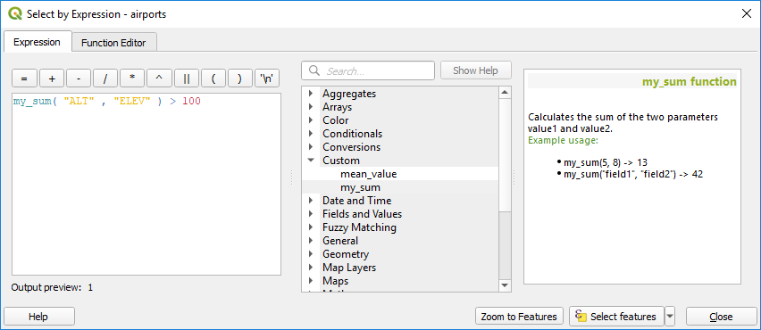
Custom Function added to the Expression tab
Se puede encontrar más información sobre cómo crear código Python en:ref:PyQGIS-Developer-Cookbook.